July 3, 2019. We are now at Sointula, which is just across the channel from Port McNeill. We came back here because we are still having problems with our alternator and charging system. Sointula means “harmony” in Finnish. This island was first founded in the 1800s by Finns as a commune. It still has vestiges of the commune spirit: hardware and grocery stores are co-operatively owned, docks have bicycles that anyone can use for free and so on. Looks like we will be here for a few days waiting for another alternator. Hopefully this one will do the job!
July 3, 2019. We spent 3 days (June 30-July2) in Booker Lagoon. We had gone ashore to try to find a path through the forest because we needed to walk around some. We went up a creek bed a short way, passing two piles of bear scat. I’ve already mentioned how unconcerned Alan is about bear scat. I immediately started making noise, yoohoo, hellooo etc. and he made fun of me. So we get back to the boat and not 20 minutes later we see not one, but TWO black bears on the beach, turning over rocks and looking for food. Right where we just WERE!!! Next morning there was another black bear on the beach in the same place. Later that day we had to go ashore to empty our compost and Alan started yelling like crazy 😜 I asked him why he thought there was a big difference between seeing bear sh*t and seeing bears. I mean really. If there is bear sh*t, then there is a bear, right?
July 3, 2019. On June 29, we tucked into a small notch in Cullen Harbor just before Booker Passage, a narrow pass into Booker Lagoon. We knew our anchorage would be available because the guidebook says NOT to anchor there because of the strong currents from Booker Passage. We found that if we tucked in tightly with a stern tie, we were mostly out of the current. Granted, we were only in six feet of water at low tide, but six feet is not aground, right?
On our way here from Crib Island we passed a rock with a pile of sea lions on it.
Sea lions on rock at outlet of Fife Sound. Cullen Harbor. I caught three fish here.
July 3, 2019. We lost Roger about a week ago so these next entries are catch-up. We spent June 27 and 28 in a little notch on Crib Island. It was quite lovely, not on the charts or guidebooks, very quiet and peaceful.
Crib Island anchorage. Crib Island dinghy exploration. Crib Island dinghy exploration 2. Crib Island dinghy exploration 3.
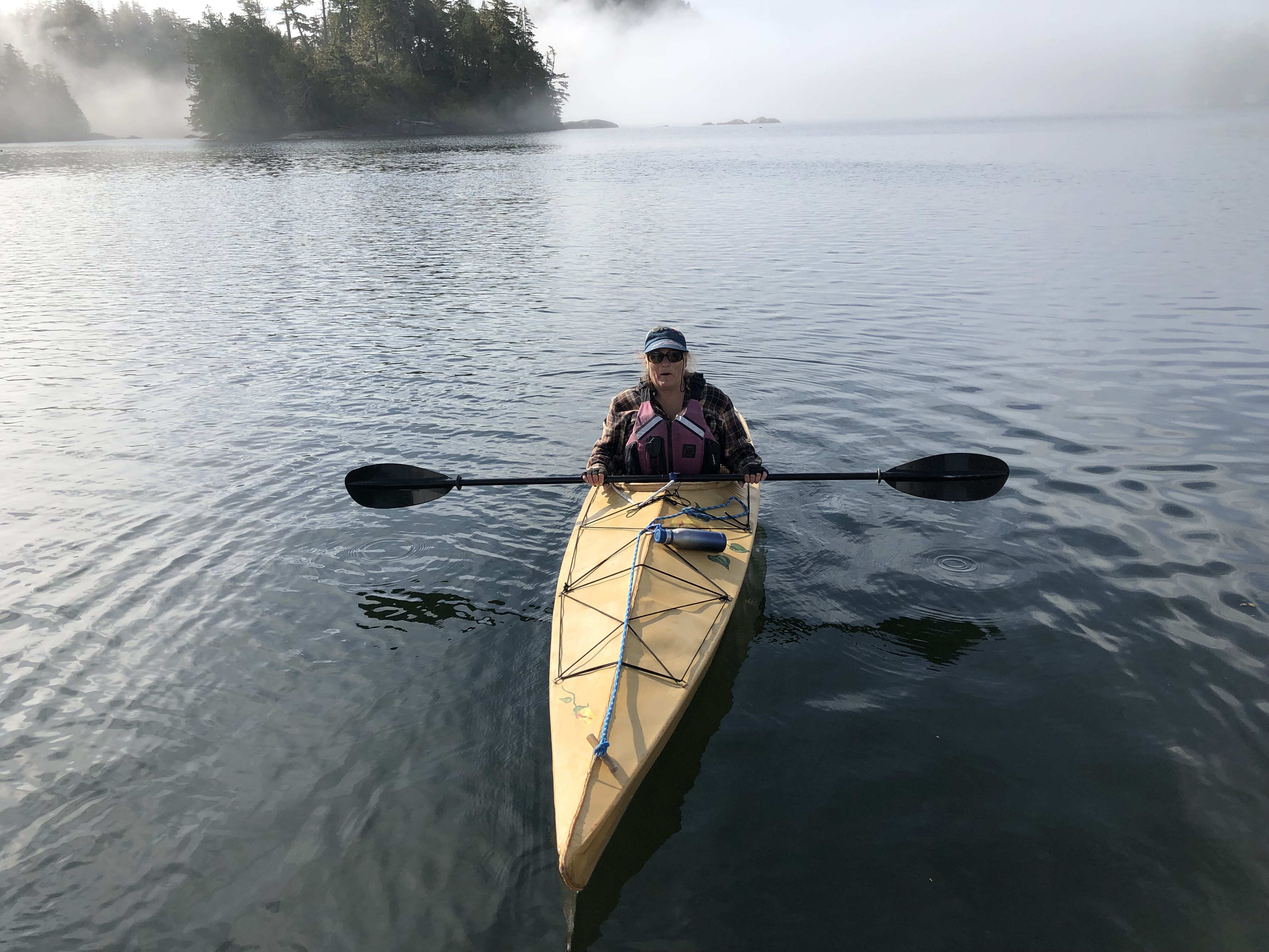
Wednesday, June 26. Another Furry Eyeful Alert. We picked our way through rocks and islets through a very narrow channel to get to this beautiful anchorage. There are supposed to be lots of whales here but we haven’t seen any. This anchorage isn’t in the guidebooks so, except for a few kyakers passing through this morning, we have had it all to ourselves. This is a kayaker’s heaven. I spent a couple of pleasant hours paddling around islets and exploring nooks and crannys.
Kayaking, Dusky BayEntrance to Dusky Bay. Yes, it really is there, right around that corner. Dusky Bay, looking west toward Queen Charlotte Strait. You could get through there. If you had to. At high tide. Bonwick Island Dawn, Dusky Bay
Tuesday, June 25. Furry eyeful alert!! We were about to head north past Cape Caution from Alert Bay but we were advised not to because we have no radar. It isn’t a problem now but August, when we return, is known around here as Fogust. So we decided to spend the rest of the summer exploring the Broughtons and going up Knight Inlet later in August instead. Radar on the list to add next winter.
We were able to sail about 1/3 of the way from Alert Bay on a beam reach turning to a broad reach. We made it all the way to the anchorage without having to tack or jibe. That’s a good day! It’s impossible to get a good pic of a sailboat when you’re ON the boat, but here we are:
Sailing up Knight Inlet
There is a lot to explore here but, to avoid the crowds, we are now choosing anchorages that are NOT listed in the guidebooks. This is called “gunkholing.” We haven’t been able to determine what characteristics an anchorage has to have to make it into the guidebooks. We have found many perfectly good ones that aren’t, so this is our current mission. Here are some pics from this one. We think you’ll agree there ain’t nothin’ wrong with this!
Looking southeast. Village Island and Vancouver Island in background. The anchorage, Midsummer Island. Looking east. Dawn. Looking northeast.
Sunday, June 23. Early last week we had to go back to Port McNeill because our alternator stopped working and we needed to replace it. On our way back to the Broughton Islands we decided to stop at Alert Bay and we ended up staying here for four days. Alert Bay is a village of mostly First Nation peoples, called the ‘Namgis. If I have understood this correctly, the ‘Namgis are made up of five Bands (we would call them Tribes) whose original villages were on north Vancouver Island, the Broughtons, Knight Inlet and Kingcome Inlet. Each of the bands have their own creation story involving a creature of some sort who is their ancestor. The creature who is the ancestor is the totem associated with that particular band. They are: thunderbird, thunderbird’s younger brother, sun, sea serpent and wolf. If a house has a totem pole with a thunderbird at the top, for example, then the people in that house belong to the band whose ancestor is the thunderbird. *
A museum/Cultural Center, called U’mista, houses masks and other ceremonial regalia that was confiscated and recently returned by the Canadian government.
The people here are very welcoming and willing to share their culture. The first evening we were invited to the unveiling ceremony of a mural painted by the children. The walls were also covered by the children’s artwork. Then they had a feast.
The Mural
This was done by a six-year old boy!
The next day was National Aboriginal Day. Celebrations started with a parade ending at U’mista with drumming and dancing followed by a feast. Then came stories and cedar bark weaving (I made a bracelet) and “Indian baseball.” The rules to the baseball are crazy, made up and agreed upon by the players before each game. In one version, after a foul tip is caught by the catcher, everyone has to freeze. The first person to move is out. After baseball was a feast. Then more drumming and dancing.
This last feast featured salmon grilled over an open fire served with Ooligan oil. Ooligan oil is very precious, made from Ooligans (Eulachon, a small, oily fish in the smelt family). The Ooligans are caught at the head of Knight Inlet (the longest inlet) every year (in the spring, I think). The oil is highly prized and was traded far and wide. The trails over which it was carried and traded were known as the grease trails. We were told that we were fortunate to be offered Ooligan oil. I tried it and it was ok. I think it’s probably an acquired taste. It’s very strong. Alan couldn’t eat it.
U’mista Entrance. Photos were not allowed inside.
There are totem poles everywhere! There is the tallest totem pole in the world in front of the long house, an old graveyard filled with commemorative totems, a newer graveyard with crosses incorporating totems (culture clash?) and totems in front of houses and buildings. A totem is created and set up then never repainted or repaired in any way. It’s allowed to deteriorate and eventually revert back to nature. We were told the only exception is the guy wires you can see on the “tallest totem pole in the world.” The guy wires are the only thing that has been done. The pole itself is very weathered.
Long House
World’s tallest totem pole
At top is the Sun, indicating the people who live here are of the band associated with the sun.
New graveyard.
Old graveyard entrance
Old graveyard.
Finally, on the third day, we had time to hike one of the many beautiful trails.
Calliope is on the inside at the far end of the right-most dock.
WTF?
Swamp at the very top of the island fed by underground spring.
*Any mistakes, misrepresentations, misspellings or other errors are due solely to my ignorance.
Monday, June 17. Furry Eyeful Alert! After cruising by the Chief’s Bathtub, we found a beautiful and peaceful spot behind the Goat Islands and up against Crease Island. We had to pick our way through islets and rocks, but it was worth it. We had intended to only spend one night here but it was so peaceful and lovely that we stayed an extra day. Awesome views in all directions.
Dawn, looking past Goat Islands toward Knight InletSunset, looking east through Goat IslandsSunset, looking west toward Crease Island Early morning mistGoat Islands, looking east toward Vancouver Island. Early morning mist.
Monday, June 17. On Saturday we left our anchorage at Dead Point Bay and cruised by the Chief’s Bathtub. The Chief’s Bathtub is a depression at the bottom of a shear rock wall that fills at high tide and empties at low. We went by when the tide was high. There are pictographs on the rock wall above the bathtub (how?) that, except for a faded face, are too dim to make out. I have enhanced the images of the face, but it doesn’t help much. I am intrigued that this face is seen all over the Pacific Northwest, as far south as the Columbia River Gorge (one there called “The Watcher”). Maybe it’s just a face and a face is a face, but these are all the same. Some are carved into granite stones that are only visible at low tide. It is also the case that the stylized art found on totem poles and paintings are the same throughout the region.
Chief’s Bathtub at bottom of image. Looks like some illegible pictographs above the bathtub. Face pictograph at far left (partial). Face pictograph, original. Face pictograph, enhanced. Face pictograph, close-up. Face pictograph, enhanced. Looks like s/he has long hair. Face enhanced. Face, enhanced, colors inverted.